Create an Optimal Territory Alignment
Learning Objectives
After completing this unit, you’ll be able to:
- Select and compare territory changes.
- Add new territories.
- Optimize and save territories.
In the previous unit, Linda laid the framework for planning territories by creating a data set and importing her existing territory alignment. Now it’s time to make changes to her territory alignment.
Inside Sales Planning, Territory Planning data is isolated from production data and assignments. This means Linda can make changes and see the immediate impact of these changes on annual revenue and unit count. Changes are not updated in Salesforce until data is published and activated.
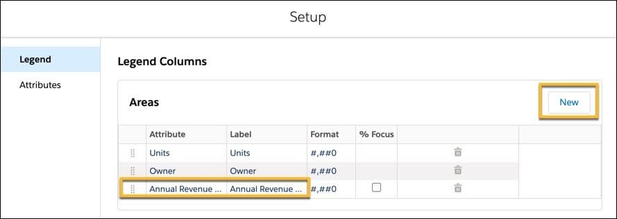
Linda starts the realignment process by reviewing the legend on the right side of the map. It displays key fields from the Accounts by Annual Revenue report she selected in her data set. In the legend, she sees each territory represented as a different color on the map, and the unit count and owner name, but she’s missing the annual revenue field. To add this as a visible column, she selects  and updates the map legend to display Annual Revenue. This brings this key datapoint to the forefront for her in the design process. She can bring in other Salesforce fields in addition or instead in order to enhance her planning.

Assign Nearby Containers
Linda shifts her attention to the map view. She’s excited to see that all the areas in the Southeast region were automatically assigned a territory.
In the past, there were often gaps in territory coverage due to missing zip codes in her Salesforce org. It took hours to search for unassigned areas, locate nearby accounts, and assign ownership. Now with Territory Planning, Linda selects Automatically assign nearby containers as part of her alignment design. Missing zip codes/postal codes are automatically assigned to nearby accounts based on their proximity to each territory.
Each territory displays a circle that represents the center of the territory. Units are scattered throughout the map. Under the Legend panel, Linda selects United States Postal Code to see the list of zip codes missing from her org. She unchecks any area she wants to keep unassigned.

Comparison Data
Now she’s ready to make changes to account assignments. Focusing on one area of the map, she uses the  tool to quickly capture a specific area for further analysis.
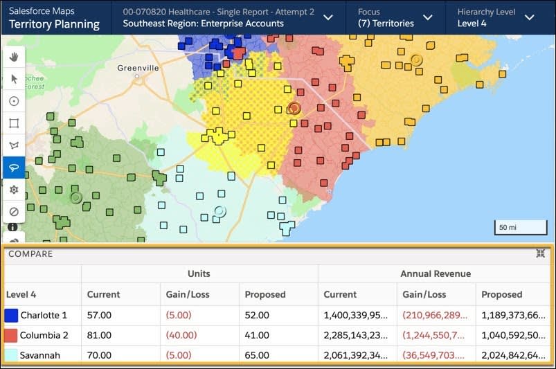
She wants to see a comparison of the annual revenue in her current alignment versus the annual revenue of any proposed changes. To view this, as an option, Territory Planning displays a comparison chart at the bottom of the map. Linda drags the lassoed area to different territories and uses the comparison chart to view the impact of these changes on the annual revenue of each selected territory.

The Power of the Legend
Once satisfied with her proposed changes, Linda selects the territory area, reassigns it to another territory, and applies her changes. The changes automatically display in the Legend fields.

Before making additional changes she selects  to share comments and collaborate with her leadership team.

After communicating with leadership, Linda uses the  on the Legend panel to create a new territory. She then assigns it to a new sales rep.

At this point, Linda has changed the assignment of territories and created a new territory. She sees the territory distribution among reps and by glancing at the unit count and annual revenue in the territory, it’s clear that they’re not evenly distributed. To solve this issue, she selects Optimize to ensure an even distribution of territories based on annual revenue. She wants every territory to have the appropriate coverage, and she also needs to ensure the reps have an equal chance to succeed. This results in happier customers, on average, and greatly reduces costly attrition.
Practice with the Trailhead Simulator
In this unit, Linda made changes to her territory alignment. Now you can practice using the Trailhead Simulator. You use the simulator instead of a Trailhead Playground to follow along and try out the steps in the simulator.
For the best experience, view the Trailhead Simulator on a computer, not a mobile device. The Trailhead Simulator is different from a Trailhead Playground. The simulator doesn’t store your progress or the data you enter. If you close your browser, the simulation starts from the beginning each time you launch it. You can use the navigation controls at the bottom of the simulator to find where you left off.
Launch the Trailhead Simulator.
Intelligent, Attribute-Based Optimization
Optimization is a powerful feature of Territory Planning; it optimizes territories based on the attribute that matters most. In this case, Linda wants to balance her territories based on annual revenue and uses distance logic to determine the actual drive time between accounts. Distance logic provides two options.
-
As the Crow Flies: Relies on straight line, point-to-point distances
-
Drive Time Network: Relies on local road networks, estimated distance, and estimated drive times
Linda selects Drive Time Network.

Now she can set her preference for optimization. There are three optimization options.
-
Balance: Provides an equal distribution of the selected attribute across territory areas
-
Continuity: Provides the minimum amount of Unit/Container reassignments across territory areas. If selected this will increase balance with minimal impact on your alignment.
-
Compactness: Provides the minimum distance between Units and Containers within Territory Areas. Smaller drive time networks decrease mileage. Use this if your organization is focused on minimizing drive time.
With Territory Planning, you can prioritize one, a combination of two, or all three options. Linda selects all three.

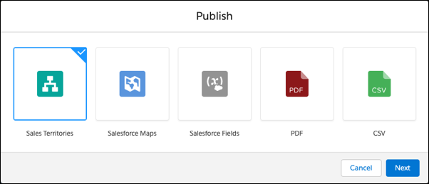
Satisfied with her design, she collaborates with leadership. Once finalized, she publishes her design. She must choose from the following six publishing options.
-
Publish to Sales Territories: Publishes a Salesforce Territory Model in Sales Territories. If selecting this option, changes must also be activated in the respective tool for changes to apply.
-
Publish to Salesforce Maps: Saves territories as shape layers in a folder in Salesforce Maps. If users have access to the folder, they can view their territories, overlay account information, and plan optimal routes and schedules within their assigned territories. Optionally creates Auto Assignment rules to geographically route records to the correct user.
-
Publish to PDF: Create PDF representations of both map and map legend for all specified layers of an Alignment. Select between current level or individual territories.
-
Publish to Salesforce Fields: Writes assignment values from Territory Planning to fields found within Salesforce records such as Accounts, Opportunities, Leads, and Custom Objects.
-
Publish to CSV File: Create a CSV extract for your alignment and include area, boundary, and/or unit information.
-
Publish to Field Service: Create service territories and service territory polygons from your assigned boundaries in Territory Planning to use in Field Service.
Linda selects Sales Territories and clicks Next.

The Sales Territories dialog box contains the following options.
-
Publish Scope: This offers two options: Publish your entire alignment or the specific focus you are working in.
-
Publish Level: This selects a hierarchy level to publish.
-
Publish Method: This publishes new territories, overwrites existing territories, or overwrites matching territories.
-
Territory Model: This is the model that the territories are published to.
-
Parent Territory: This selection determines the parent territory for the selected level.
-
Territory Type: This is the territory type that is assigned to every territory in the alignment.
-
Assignment Rule Field: This selects any standard or custom account field to base your territory assignment rules on, such as zip code or state.
-
Publish locked units as manually assigned accounts: If a territory contains locked accounts, then they can publish those assignments manually. This is typically for exception accounts that do not match the geo assignment rules (that is, an account in a zip code that is owned by a different rep).
Linda completes the dialogue box and publishes her new alignment.

In this case, she also chooses Publish to Salesforce Maps. She saves the territory shape layers in a folder accessible to the sales team. Now the Cloud Kicks sales team can use these additional shape layers in Salesforce Maps to graphically visualize their territories and create optimized routes and schedules to improve productivity and revenue.
Conclusion
Throughout this unit, Linda worked to realign territories for Cloud Kicks. She successfully visualized new territories and easily made changes using Territory Planning. Changes to key attributes were automatically updated and she saw the immediate impact of any change. All the while, her realignments were isolated from production data so Linda can safely make as many changes as needed and share realignments with management before activating any final changes.